Marshall Fire

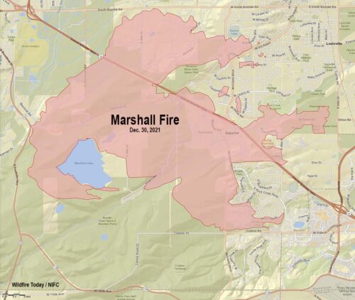
Site Tour 360 was engaged by the University of Hawaii, in conjunction with the National Disaster Preparedness Training Center and the National Science Foundation, to conduct an extensive 360 imagery collection on the areas directly affected by the Marshall Fire

On December 30th 2021, what started out as a grass fire, quickly became the most destructive fire in Colorado history in terms of structures lost. The finished collection consisted of xxxx georefernecd panoramas compiled into an easily accessible interactive map.

The basic interactive map was synchronized with Google’s most current Street View imagery to provide the ability to directly compare before and after 360 imagery of the entire affected area. 

Additionally, the collected imagery was utilized to study possible correlations between socio-economic factors (ie social vulnerability) and the severity of damage to specific areas of the community.

An additional goal of the project was to assess the viability of deploying a very compact, portable & easy to use 360 imagery collection system on an actual real-world project.

labpano_pilot_one_ee_128_pilot_one_ee_8k_1654616
Lab Pano Pilot EE 360

This system revolves around the use of the Lab Pano Pilot EE 360 camera and two custom designed camera mounting systems (for vehicle mounting and for hand carrying) . The imagery for the entire project was successfully collected with this camera system, without any errors or difficulties.